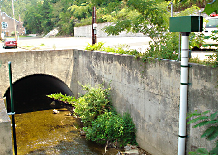

Hot Springs, Arkansas, is a history-rich city located adjacent to Hot Springs National Park. The city is blessed with mountainous terrain, recreational waterways, and more than 45 hot springs. Hot Springs Creek delivers spring water through the center of town. In 1884 the creek was enclosed, and the arch over the creek now serves as the base for Central Avenue. The surrounding mountains are of steep relief and expose large areas of nonporous bedrock. This combination of hydrology, topology, and geology make city infrastructure, especially Central Avenue, highly susceptible to flooding during microburst rainfall events.
Since 2008, the city of Hot Springs has worked cooperatively with the USGS Arkansas Water Science Center to maintain and operate their flood-warning information system. The system serves to provide timely flood information to city officials, first responders, and the regional National Weather Service offices. With proper warning, swift-water rescue teams can be readied, roads prone to flooding can be barricaded, and low-lying public areas can be evacuated.
The Arkansas Water Science Center has a yearly agreement with the city of Hot Springs to maintain the system. The USGS maintains all equipment, exercises functionality, and performs the needed discharge measurements to maintain flow models and stage-discharge relationships.
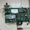
In 2013, the flood-warning information system was updated. Campbell Scientific hardware and software were chosen for their reliability and capability. In all, nine gaging stations and the base station were overhauled, plus another base station and camera were added to the system in 2014. The camera has pan, tilt, and zoom capabilities, and is available for real-time viewing to emergency personnel.
Six of the stations report stream stage and rainfall. Each station contains a CR1000 datalogger, NL120 Ethernet interface, COM320 voice-synthesizing telephone modem, and GOES satellite transmitter. Data is reported via the Internet and the GOES system. Alarms are delivered directly from the station via text and interactive phone messaging. Three of the stations report rainfall only. Each station contains a CR1000 datalogger and cellular data modem. Data are reported via the Internet, and alarms can be delivered directly by email or texting if needed.
At six stations, the CR1000 acts as an SDI-12 recorder and an SDI-12 sensor. As an SDI-12 sensor, the CR1000 shares measured data with a SatLink-V2 GOES DCP. GOES serves as a redundant telemetry path, feeding 15 minute data to the USGS National Water Information System every hour. Since being installed in 2013, the system has been tested by multiple high-intensity, short-duration rainfall events. During one event, power and internet service were lost at two of the stream gages, but data delivery was not interrupted due to the redundant communication over the GOES random channel.
The two bases consist of a computer with Campbell Scientific’s LoggerNet, RTMC Pro, and CSI Web Server software installed. Additionally, at the base is a CR1000 datalogger with an NL120 and a COM320. The software is used for data collection and display, including a web page for viewing real-time data by emergency personnel. The RTMC web page is configured to display gage rain and stage values, stormwater system level, and 48 hours of time-series gage data. The base datalogger provides redundancy, collecting data over the Internet independent of the base computer. The base datalogger issues alarms via text message and interactive phone messaging when user-defined thresholds have been met for gage height or hourly rainfall. Alarming key personnel is the most important function of the system. The base station also sends daily summary emails to cooperators during normal flow conditions.
The Arkansas Water Science Center, with Campbell Scientific training and technical support, has successfully implemented the needed improvements to the City of Hot Springs flood-warning information system. The system has already proven its improved reliability and flexibility under actual storm conditions. For more information regarding the City of Hot Springs flood-warning system please visit the following website: ar.water.usgs.gov/hotsprings.
Case Study Summary
Application
Six gaging stations updatedLocation
Hot Springs, Arkansas, USAProducts Used
CR1000 NL120 COM320 RAVENXTV LoggerNet RTMC ProContributors
Joey Fleming, USGS Arkansas Water Science CenterParticipating Organizations
U.S. Geological Survey (USGS)Measured Parameters
Rainfall, stream stageControlled Devices
Voice and text messaging, alarmsView the PDF