The Delaware Environmental Observing System (DEOS) is a real-time system dedicated to monitoring environmental conditions across the State of Delaware, the near-shore coastal waters and the Delaware Bay, and adjacent regions of Maryland, Pennsylvania, and New Jersey. DEOS is a tool for decision makers involved in emergency management, natural resource monitoring, agriculture, transportation, and other activities throughout the State of Delaware and the Delmarva Peninsula. It is a cooperative venture with a number of state and federal agencies, and many of its visualization and analysis tools are designed to be adaptable outside Delmarva.
DEOS consists of:
- DEMON—The DEOS Environmental Monitoring and Observing Network is a network of meteorological observation sites in and around Delaware.
- DIVAS—The DEOS Integrated Visualization and Analysis System integrates surface weather observations with NWS WSR-88D radar estimates of precipitation. This provides estimates of meteorological and environmental variables over a high spatial resolution grid using ESRI's ArcGIS 9 Server.
- DEOS Analysis Systems—Provides easy access to data stored in an Oracle database, allowing informed decision making for a variety of environmentally sensitive areas.
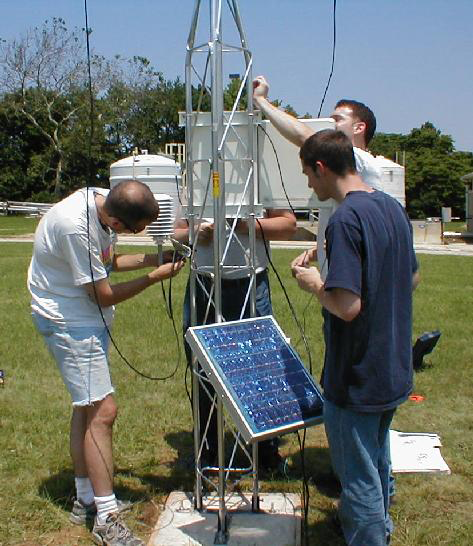
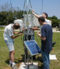
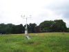
DEMON integrates a number of meteorological and hydrological observation sites throughout Delaware and surrounding areas. Observations include both meteorological (e.g., wind vector, air temperature, precipitation, humidity, atmospheric pressure, soil moisture, and solar radiation) and hydrological variables (e.g., streamflow, water quality, tidal heights, well levels) with spatially interpolated fields of a number of observed and derived variables. Data are provided in real time to a number of state and federal agencies, including the National Weather Service.
DEOS stations have been installed in all three counties of Delaware as well as Chester County in Pennsylvania and Cecil County in Maryland. By the end of Summer in 2005, we will have 22 Campbell Scientific-based stations on-line through DEOS, the Delaware Solid Waste Authority, the Natural Estuarine Research Reserve, and the University of Delaware's Agricultural Cooperative Extension—all in a five-county area.
On some sites, we also have installed a 237 Wetness Sensing Grid and an SR50 CSC Ultrasonic Distance Sensor for snow depth measurement.
A significant effort is directed toward providing quality control and assurance (QA/QC) and preventive maintenance for the sensors. If a station failure is detected, the system contacts DEOS personnel.
DEOS provides more than data acquisition and dissemination. To date, the DEOS system has proven useful in a number of environmental applications. During the passage of tropical storms, nor'easters, or heavy snowfall, DEOS staff works with the Delaware Emergency Management Agency (DEMA) to provide up-to-date information on developing weather events. DEOS can also alert state personnel and the 911 Center when exceptional conditions occur (e.g., heavy rainfall, high streamflow, excessive heat).
DEMA also uses DEOS data to assist with developing emergency management situations, such as toxic spills, hazardous chemical releases, and flash flooding events. The Delaware Department of Natural Resources and Environmental Control regularly uses DEOS data to provide information for pesticide management, mosquito control, and to schedule controlled burns of invasive plant species along the coast. The Delaware Solid Waste Authority and the Southeastern Chester County Refuse Authority have used the data to assist with refuse disposal activities. BP Solar has expressed interest in working with DEOS to test the durability of their solar panels for use in marine environments.
We hope that DEOS will become the highest resolution, most comprehensive state or regional environmental monitoring network available anywhere.
In a May 21, 2018 newscast on WBOC News, there is a feature on DEOS, which you can watch on YouTube.
Case Study Summary
Application
Meteorology and hydrology as resources for multiple agenciesLocation
DelawareProducts Used
CR10X HMP35C-L CS105 TE525 107 CS616 LI200X-L 03001-L 05106-L 237-L SR50-LContributors
David R. Legates and Daniel J. Leathers, University of DelawareParticipating Organizations
Delaware Emergency Management AgencyMeasured Parameters
Air temperature, barometric pressure, relative humidity, precipitation, soil moisture, soil temperature, solar radiation, snow depth, water temperature, wave height and period, wind speed and directionView the PDF