Mesonet Essentials An introduction to mesonets, their value, and how they work

Mesonet Essentials is a resource created in collaboration with members of the American Association of State Climatologists (AASC) and the national mesonet community. To learn more about the AASC vision, mission, goals, and membership opportunities, visit their website at www.stateclimate.org.
What is a mesonet?
The term "mesonet" (pronounced "meh-zoh-net") is derived from the words "mesoscale" and "network." In meteorology, a mesonet is typically a network of collectively owned and operated automated weather stations that are installed close enough to each other—and report data frequently enough—to observe, measure, and track mesoscale meteorological phenomena. Mesonet stations are also often used to measure climatological variables to model the biophysical processes of vegetative canopies. The automated weather stations are left unattended at field sites for extended periods to measure several parameters, and the data from the network of stations are transmitted to a base station at a central data processing center.
The geographic area for mesoscale encompasses a horizontal extent ranging from a few kilometers to several hundred kilometers. Within the mesoscale area, the weather stations are typically positioned anywhere from a few kilometers to tens of kilometers apart.
Resource: For more information about the optimal spacing of stations, see the Network Design section.
Mesoscale meteorological phenomena last between several minutes to several hours and include thunderstorms, heat bursts, wind gusts, dry lines, squall lines, heavy downpours, tornadoes, and hurricane eyewalls. Mesonet weather stations may report data on these phenomena as frequently as every 15 minutes or less.
Note: While the term "mesonet" is used throughout this discussion, there are several other terms that have been used to refer to the same concept. These include phrases such as large environmental monitoring network, weather monitoring network, and weather station network.
“About the Oklahoma Mesonet,” Board of Regents of the University of Oklahoma, accessed June 19, 2017, http://www.mesonet.org/index.php/site/about.
“Mesonet,” Wikipedia, accessed June 19, 2017, https://en.wikipedia.org/wiki/Mesonet.
“Mesoscale,” American Meteorological Society, accessed June 19, 2017, http://glossary.ametsoc.org/wiki/Mesoscale.
What value do mesonets provide?
Each mesonet’s purpose and application are heavily dependent on the specific needs of its stakeholders while respecting the constraints of the budget allotted for the mesonet project. For example, while it might be ideal to measure many different parameters, outfitting all the weather stations in a network with the many sensors needed to acquire all these measurements may be cost prohibitive.
Mesonets serve many purposes and can provide data to a variety of stakeholders who use the data for a myriad of purposes. The data can be used to make decisions in many areas, including the following:
- Agriculture
- Education
- Emergency management
- Energy industry
- Environmental research
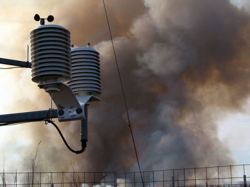
- Management of prescribed burns and wildfires
- Transportation
- Weather forecasting
Because of the dense population and frequent data reporting of its weather stations, a mesonet can provide real-time 24/7 weather intelligence on a local to regional basis. Weather monitoring networks provide critical, quickly changing data about localized weather conditions that may be significantly different from the conditions of a larger-scale area.
Mesoscale weather events are often dangerous with a substantial impact on lives, property, and operations. With more localized information, short- and medium-term weather forecasting can be improved down to the local scale, weather alerts can be issued, and climate monitoring can be performed on a regional basis.
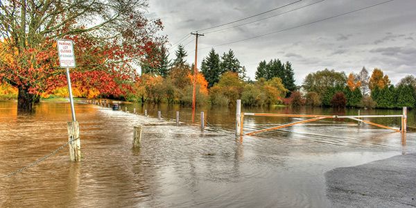
Because many mesonets were developed to meet agricultural needs, those weather monitoring networks are a helpful resource in providing historical and current data for drought and flood determination and warnings. The network weather station data can be used to do the following:
- Help farmers determine when to irrigate
- Aid water management districts for regulation and control
- Observe phenomena of university and extension research projects
- Monitor climate trends
- Develop education outreach programs
- Help warn public emergency management of severe weather and flooding
“Benefits – Overview,” Board of Regents of the University of Oklahoma, accessed June 19, 2017, http://www.mesonet.org/index.php/site/about/benefits.
David A. Robinson, “Societal Benefits of Mesonets: a New Jersey Example” (presentation at 22nd Conference on Applied Climatology, New Orleans, Louisiana, January 11, 2016). https://ams.confex.com/ams/96Annual/webprogram/Paper284767.html.
“What is the Oklahoma Mesonet?,” Oklahoma Climatological Survey, 1997. http://www.mesonet.org/files/materials/mesonet.pdf.
What does a mesonet measure?
Mesonet weather stations measure and collect data that are deemed important to the purpose of the network. Consequently, each network of weather stations may measure different meteorological parameters.
The following are some common parameters that many mesonet stations measure:
- Air temperature
- Barometric pressure
- Rainfall amount
- Relative humidity
- Soil moisture
- Soil temperature
- Solar radiation
- Wind direction
- Wind speed
The versatility of high-quality mesonet stations enables the addition of other types of sensors to a mesonet to acquire measurement data for parameters that are specialized to an application’s location. In addition, mesonet stations may also be equipped with cameras to capture relevant images.
Resource: For more information about parameters and selecting sensors, see the Station Design section.
“AASC Instrumentation and Data Standards Committee Report,” The State Climatologist 9, no. 4 (October 1985): 12-14. http://www.stateclimate.org/sites/default/files/upload/pdf/state-climatologist/00000029.pdf.
Jarraud, M. "Guide to meteorological instruments and methods of observation (WMO-No. 8)." World Meteorological Organisation: Geneva, Switzerland (2014): 233. https://library.wmo.int/opac/doc_num.php?explnum_id=4147 (2014 version updated in 2017).
Jerald A. Brotzge, C. D. Thorncroft, E. L. Joseph, C. Appleby, N. Bain, N. Bassill, N. Farruggio, Z. Gao, K. Hemker, D. Johnston, E., Kane, S. McKim, P. Naple, S. Perez, J. Schwab, J. Sicker, J. Wang, B. Yin, and J. Yun, “The New York State Mesonet: A General Overview” (presentation at 97th American Meteorological Society Annual Meeting, Seattle, Washington, January 22-26, 2017). https://ams.confex.com/ams/97Annual/videogateway.cgi/id/38128?recordingid=38128&uniqueid=Paper313185&entry_password=205198.
Observing Weather and Climate from the Ground Up: A Nationwide Network of Networks, (Washington, DC: The National Academies Press, 2009). https://doi.org/10.17226/12540.
“Portable mesonet stations,” American Meteorological Society, accessed June 19, 2017, http://glossary.ametsoc.org/wiki/Mesonet_station.
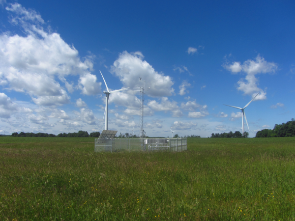
How does a mesonet work?
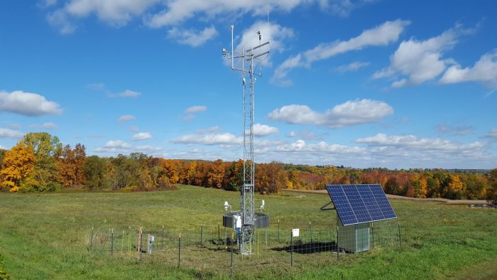
Typically, mesonets cover an area the size of a state or county, and the stations tend to be equally spaced apart. For example, in a statewide weather station network, there may be one or more weather stations per county. Each weather station within the mesonet is independent and is powered by a battery that is charged either with solar panels or an ac source. The weather station equipment is typically mounted to a tripod or tower.
At each mesonet station, the meteorological sensors measure the various parameters and provide electronic signals, which are scanned by the station data logger. The data logger converts the sensor signals to digital values, which are stored in the data logger memory.
Each weather station’s data logger typically transmits the data to a base station at a central data processing center via radio, telephone, or satellite transmission. Using specialized software, the data from all the mesonet weather stations are collected, reviewed for quality control/assurance, formatted for internal monitoring and the necessary data products, and distributed to the mesonet stakeholders.
“Overview,” Kansas State University, accessed June 19, 2017, http://mesonet.k-state.edu/about/.
How does quality affect a mesonet?
At their very best, mesonets provide high-quality data. To achieve the best data, however, is a process. First, the mesonet planner must select high-quality equipment that will provide the best measurements relative to the budget for the network project. Then, the equipment operator must regularly maintain and calibrate the equipment to ensure it continues to provide the best possible measurements. (If, in the future, improved products become available, the stakeholders must be willing to thoughtfully consider upgrading their weather stations.)
High-quality automated weather stations not only provide higher-quality mesonet data, but they also enable operators to examine the data before it is shared. High-quality stations also provide a greater variety of data deliverables to meet the needs of various stakeholders.
Mesonet operators must be willing to spend considerable time reviewing their data to ensure that the data products that they deliver to stakeholders are accurate. Operators have an obligation to flag potentially bad data during the quality assurance/control process and disregard suspect data. Operators can compare the data from one station to that of a nearby station to see if there is a discrepancy, investigate why there might be differences, and annotate the measurements. This is sometimes referred to as the metadata for the mesonet—the data that describe and give information about the measured data.
A core set of parameters may be common among various mesonets to represent the local area surface meteorology of the network, and the mesonets may share similar data output needs. There are, however, often specialized parameters that need to be measured for a particular network. High-quality weather stations often allow operators to add sensors to measure parameters that may not be common for most networks. For example, stakeholders for a mesonet in Michigan may have an interest in measuring the snowfall depth at their weather stations because the melting snow feeds into their groundwater supply. In contrast, snowfall depth in Alabama may not be a high-priority measurement for its network stakeholders.
Typically, high-quality weather stations are more rugged and designed to endure a multitude of weather conditions. In the long run, this typically reduces operational costs and downtime.
C. A. Fiebrich, C. R. Morgan, A. G. McCombs, P. K. Hall, Jr., and R. A. McPherson, "Quality assurance procedures for mesoscale meteorological data," Journal of Atmospheric and Oceanic Technology 27 (2010): 1565-1582.
“Overview,” Kansas State University, accessed June 19, 2017, http://mesonet.k-state.edu/about/.
S. J. Richardson and F. V. Brock, “System design, calibration, and quality assurance needs for networks,” in Handbook of Weather, Climate, and Water: Dynamics, Climate, Physical Meteorology, Weather Systems, and Measurements (2005).
How did mesonets get started and evolve?
Many of the mesonets in the United States came into being as the result of the research needs of agricultural land-grant universities. These universities had a mission to teach practical agriculture, science, military science, and engineering principles.
Early mesonets, however, were quite a bit different from today’s network of automatic weather stations. According to Wikipedia:
Each constituent instrument of the weather station was purely mechanical and fairly independent of the other sensors. Data were recorded continuously by an inked stylus that pivoted about a point onto a rotating drum covered by a sheath of graphed paper called a trace chart, much like a traditional seismograph station. Data analysis could occur only after the trace charts from the various instruments were collected.
Mesonets have continued to evolve and multiply across the country as computers, information, and communication technologies continue to improve. The reliability and accuracy of mesonet data continues to improve as the cost to provide such data becomes more affordable.
“Land-grant university,” Wikipedia, accessed June 19, 2017, https://en.wikipedia.org/wiki/Land-grant_university.
“NIFA Land-Grant Colleges and Universities,” Wikipedia, accessed June 19, 2017, https://en.wikipedia.org/wiki/Land-grant_university#/media/File:Land_Grant_Colleges_Map.svg.
“Mesonet – History,” Wikipedia, accessed June 19, 2017, https://en.wikipedia.org/wiki/Mesonet#History.
How many mesonets exist today?
The most current data we have indicate that there are 27 statewide mesonets consisting of 1,664 real-time weather stations.
| State | Network | Total Number of Real-Time Stations |
|
Alabama |
22 |
|
|
Alabama |
25 |
|
|
Arizona |
21 |
|
|
California |
152 |
|
|
Colorado |
91 |
|
|
Delaware |
57 |
|
|
Florida |
42 |
|
|
Georgia |
82 |
|
|
Illinois |
19 |
|
|
Iowa |
17 |
|
|
Kansas |
51 |
|
|
Kentucky |
66 |
|
|
Louisiana |
9 |
|
|
Michigan |
82 |
|
|
Minnesota |
8 |
|
|
Missouri |
24 |
|
|
Nebraska |
68 |
|
|
New Jersey |
61 |
|
|
New Mexico |
6 |
|
|
New York |
180 |
|
|
North Carolina |
40 |
|
|
North Dakota |
90 |
|
|
Oklahoma |
120 |
|
|
South Dakota |
25 |
|
|
Texas |
98 |
|
|
Utah |
32 |
|
|
Washington |
176 |
|
|
|
Total |
1664 |
In addition to these state-wide mesonets, there exist numerous other networks in the U.S., as well as mesonets across the globe.
R. Mahmood, R. Boyles, K. Brinson, C. Fiebrich, S. Foster, K. Hubbard, D. Robinson, J. Andresen, and D. Leathers, “Mesonets: Mesoscale Weather and Climate Observations for the U.S.,” Bulletin of the American Meteorological Society. http://journals.ametsoc.org/doi/pdf/10.1175/BAMS-D-15-00258.1.
Are more mesonets needed?
While it is true that many mesonets already exist, there is still a need for more mesonets and more weather stations in existing mesonets. For example, there are more than 3,000 counties in the United States, and not all these counties have a weather station. To create uniform local-area coverage across the country, more weather station networks are needed. Moreover, many existing mesonet operators are looking to expand their networks to provide complete state coverage, and states without networks are choosing to develop their own. There is a National Mesonet Program that hopes to move the U.S. in this direction. By developing extensive weather monitoring networks across the continental U.S., both breadth and depth needs are fulfilled, helping to close the current gaps that exist for local-area coverage.
Curtis H. Marshall, “The National Mesonet Program” (presentation at 96th American Meteorological Society Annual Meeting, New Orleans, Louisiana, January 11, 2016). https://ams.confex.com/ams/96Annual/videogateway.cgi/id/31841?recordingid=31841&uniqueid=Paper290349&entry_password=193017.
John Dahlia, “The National Mesonet Program: Filling in the Gaps,” Weatherwise (July/August 2013). http://www.gst.com/sites/default/files/National%20Mesonet%20Program%20-%20Filling%20in%20the%20Gaps%20-%20WeatherWise%20-%20July%202013.pdf.
“The National Mesonet Program (NMP): Building Soil Data Delivery to NOAA and Growing the Use of Mesonet Data,” Global Science & Technology, Inc., May 24, 2016. https://www.drought.gov/drought/sites/drought.gov.drought/files/media/calendar/pre_SoilMoisture2016_Heppner.pdf